
St. Mary's Place was originally built by John Dobson in 1829 to complement his church of St Thomas (opposite).
The houses were designed the in the Tudor Gothic style.
The street is named after the Hospital of St Mary Magdelene, whose medieval buildings probably stood between St. Mary's Place and Vine Lane at Northumberland Street end.
Description courtesy of Sitelines.
23rd May 2023


St. Mary's Place, nos. 2 to 12.


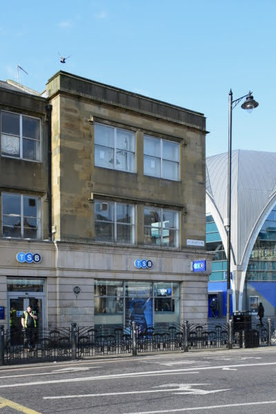
St. Mary's Place, no. 14 and St. Mary's Place East, no. 4.


St. Mary's Place, nos. 2-14.
Includes No. 4 St. Mary's Place East. 14 houses, now shops and offices. 1830 by John Dobson. Sandstone ashlar; ashlar bases to brick chimneys on Welsh slate roof. Tudor style. Basements, 2 storeys and attics; each house 2 bays except one bay to No. 4 St. Mary's Place East: 27 bays in all.
4-over-4 vertical panels to doors in Tudor-arched surrounds at left of each house; sash windows above, most of on first floor with glazing bars. C20 glazing to most upper windows and to some attics. Right bay has wider sashes on each floor. Floor and eaves strings. Half-dormers at right and in projecting left end bay under gables. All openings have drip-moulds.
Linking parapet continuous with gable has blind battlements over 6 left houses, small windows over remaining houses.
C20 ground floor shops to Nos. 2, 3, 4, 5, 7, 8 and 9; former garage showroom in No. 4 St. Mary's Place East.
Grade 2 Listed. Source: Heritage England


St. Mary's Place, nos. 26 to 38.


St. Mary's Place, no. 26

St. Mary's Place, nos. 26 and 28.

St. Mary's Place, nos. 26 to 32.

St. Mary's Place, nos. 26 to 36.

St. Mary's Place, nos. 26 to 38.


St. Mary's Place, nos. 28 and 30.

St. Mary's Place, no. 30.


St. Mary's Place, no. 32.

St. Mary's Place, nos. 32 to 36.


St. Mary's Place, nos. 34 to 36.


St. Mary's Place, no. 38.
7th December 2022


St. Mary's Place, no. 14 and St. Mary's Place East, no. 4.

17th August 2022

St. Mary's Place, no. 14 and St. Mary's Place East, no. 4.
9th June 2019


7th November 2010


St. Mary's Place, no. 14 and St. Mary's Place East, no. 4.
1995

St Mary's Place, Luckie's Bar.
The photograph shows the front and the side of the Luckie's Bar. This building is the corner block of nos. 2 to 14 St Mary's Place and no. 4 St Mary's Place East. In 2011 it became the Five Swans, a Wetherspoons bar.
Photo courtesy of Newcastle Libraries.
1981

Lord Mayor Parade, St. Mary's Place.
The Lord Mayor's Parade turns into John Dobson Street from St. Mary's Place.
Photo courtesy of Newcastle Libraries.
1969

John Dobson Street/Saville Row/St. Mary's Place.
The photograph shows the demolition of buildings between Saville Row and St. Mary's Place to make way for the new road on John Dobson Street. Buildings on Northumberland Road including Northumberland Baths can be seen in the background. The Civic Centre on St. Mary's Place is in the distance behind the Northumberland Baths.
Photo courtesy of Newcastle Libraries.
1968

St. Mary's Place.
The photograph shows the demolition of buildings on St. Mary's Place to make way for the new John Dobson Street. The building on the far right is now the Five Swans pub.
Photo courtesy of Newcastle Libraries.
1966

St. Mary's Place.
Lloyd's Bank and Northern Rock Building Society on St. Mary's Place. Northumberland St is to the right of Lloyd's Bank.
Photo courtesy of Newcastle Libraries.
1966

Northumberland Street/St. Mary's Place.
The photograph shows the shops on the left-hand side at the top of Northumberland Street. The shops include 'Wm Southern' 'Kirtons' 'Finlays' and 'Lloyds Bank' which is on the corner of Northumberland Street and St. Mary's Place.
Photo courtesy of Newcastle Libraries.
1966

St. Mary's Place.
A view from the top of Newcastle University looking down on to St. Mary's Place.
Photo courtesy of Newcastle Libraries.
1965

St. Mary's Place.
A view of St. Mary's Place looking towards the War Memorial. St. Thomas' Church is on the right. An antiques Shop and Nearly New shop can be seen on the left of the photo.
Photo courtesy of Newcastle Libraries.
1965

St. Mary's Place.
Taken from the Haymarket looking along St. Mary's Place.
Photo courtesy of Newcastle Libraries.
1957

St. Mary's Place, Newcastle Eye Hospital.
The photograph shows the front of the hospital which is derelict.
Photo courtesy of Newcastle Libraries.
1939-45

Victoria Tunnel Entrance.
Lantern Slide Description: A photograph of the entrance to the Victoria Tunnel Air Raid Shelter in the grounds of St Thomas Church. A man is standing in the entrance. In the background to the right the building is probably the end of Lovaine Hall in St. Mary's Place.
Photo courtesy of Newcastle Libraries.
1930

St. Mary's Place.
St. Mary's Place, with St. Thomas' Church to the left, buildings on right standing on site of present Civic Centre, houses in background on right behind trees is Lovaine Place and Lovaine House on the far right.
Photo courtesy of Newcastle Libraries.
Undated

G. R. Haugh Coach Works, St. Mary's Place.
An undated postcard of G.R. Haugh's Coach Works in St. Mary's Place. The view shows a man standing beside a motor van which has a crest and the intitials 'G' and 'R' on the side. A sign advertising G.R. Haugh's Coach Works is propped up against the car.
The Coach Works can be seen in the background.George R Haugh is first listed in the 1904 Directory for Newcastle upon Tyne as a cartwright by 1938 he was a haulage contractor and1940 a manager. This vehicle bears the crest of the City on its side and appears to date from the 1930's.
Photo courtesy of Newcastle Libraries.
More Information:
- Sitelines: St. Mary's Place, Eye Infirmary
- Sitelines: St. Mary's Place, carriage works
- Sitelines: St. Mary's Place, St. George's Hall
- Sitelines: St. Mary's Place, Church of Humanity (Positivists)
- Sitelines: St. Mary's Place, Lovaine Hall
- Sitelines: Barras Bridge, Hospital of St. Mary Magdalene
See my other photos around St. Mary's Place:
- Barras Bridge, Lord Armstrong Statue
- Barras Bridge, Royal Tank Regiment War Memorial
- Barras Bridge, The Civic Centre
- Barras Bridge, The Great North Museum
- Barras Bridge, The Hancock Museum
- Barras Bridge, The Response (War Memorial)
- Haymarket
- Haymarket, Metro Station (Redevelopment)
- Haymarket, Shoulder To Shoulder (Lego Men)
- John Dobson Street
- Northumberland Street
- Northumbria University
- Percy Street
2 comments:
St Mary’s place…the takeaway shop with the get stuffed sign above the door….that used to be the stone art gallery….often frequented by LS Lowry….I have photos of him standing at that very door
Great memory, thank you. I don't remeber the gallery, I must be too young. Please get in touch if you would like to share any old photos with us.
Post a Comment