Burradon is a village in North Tyneside around 5 miles to the north of Newcastle upon Tyne. It is adjacent to Camperdown and the two villages are closely linked. Camperdown was once known as Hazlerigge.
History
Burradon has been occupied since the 5th or 6th century B.C. In 1317 John de Weetslade (Camperdown) joined a rebellion against the King. The rebellion failed and John was stripped of his land, which was granted to William de Heslerigge.
Between 1820-1828 a small coal pit was sunk and marked the beginnings of the community, as it is known today. From 1829–1858 the centre and culture of village life moved from the old medieval settlement surrounding the farm to the ever expanding colliery village of Camperdown. In 1860 a mining disaster made the community famous countrywide. From 1895-1914 living conditions gradually improved and the mining families took control over their own affairs with the building of a Co-op store and working men's social club.
Economy
In 1820-1828 a small coal pit was sunk by Lord Ravensworth & Partners and marked the beginnings of the community, as it is known today. From 1829–1858 the centre and culture of village life moved from the old medieval settlement surrounding the farm to the ever expanding colliery village of Camperdown. In 1860 a mining disaster made the community famous countrywide. The colliery closed in November 1975. Little remains of the colliery except for the old Seaton Burn wagonway which was the boundary between Burradon and Camperdown.
Burradon Mining Disaster
On 2 March 1860, an explosion took place at Burradon Colliery killing seventy-six men and boys. The disaster became of national interest and significance. At this time laws were inadequate at ensuring the safe operation of collieries and the families of disaster victims would have to rely on charity rather than compensation.
The inquest and newspaper coverage of the disaster (mostly the involvement of the Newcastle Chronicle) took issue with who should be responsible for both compensation and mine safety in what was to become a hotly contested debate. A group of the more senior Burradon miners: Maddox, Carr, Urwin (and Baxter Langley, editor of the Newcastle Daily Chronicle) had been at the forefront of a campaign to set up an insurance scheme for miners hurt or killed down the pit. The mine owners procrastinated on this proposal. The mineworkers had enlisted the help, and won great respect, from the editor and owner of a local newspaper, who supported their case with everything at their disposal. The anger felt towards the mine owners and the vigour with which the subsequent trial was fought was all the greater because the disaster had been predicted.
Description courtesy of Burradon, Tyne and Wear - Wikipedia.
24th February 2010
Burradon Farm, Farmhouses and Cottages.
A plan of the Burradon Estate of William Ogle Wallis Ogle of Causey Park dated February 14th 1804 shows two adjacent farms at the centre of the estate lands, one of which consists of a courtyard of buildings attached to the east and south elevations of the pele tower, the second being an elongated range of three separate buildings to the north of the tower.
Each farm has its own stack yard and garth. By 1st edition Ordnance Survey map of 1858 buildings had been added in-between the older buildings and a gin-gan had been built onto the north facing wall of the centrally located threshing barn. In the second half of the 19th century there were major changes. With the exception of the ancient tower and two cottages relating to the nearby quarry, all the farm buildings were removed. The farmstead attached to the pele tower was demolished completely.
Burradon House was built to the west of the tower with a range of buildings fronting onto the roadway through the site - this still exist. The farmstead to the north of the road was also removed and a new range of farm buildings constructed. Other than the addition of timber barns to the rear of the stone buildings, the plan the buildings today is that which had developed by the end of 19th century.
The new farm was based on the introduction of steam power and the construction of a long two storey range on an east-west axis forming the spine of the farm. Typically the engine house with its attendant chimney protruded from the rear of the threshing barn at the centre of this range. On the south elevation were a series of arched entrances at ground level with window openings above. A series of foldyards were created by the construction of single storey ranges extensing southwards from the main buildings. The eastern elevation of the easternmost range was left open as a cart shed and a smithy stood at its southern end. Most of the buildings have survived.
Source: Sitelines.
Burradon Recreation Ground.
Burradon Primary School.
Burradon Road.
Front Street.
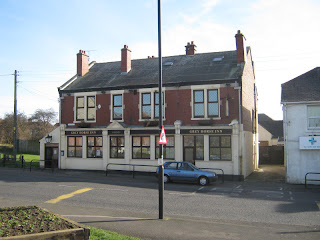
Front Street, The Travellers Rest.
Fryers Millennium Green.
Pretty gardens created in 2000 to celebrate the millennium. Built on the line of the Seaton Burn Waggonway and takes its name from Fryer's Terrace, which formerly occupied this plot.
Source: Sitelines.
Kirkwood, Church Of The Good Shepherd.
Front Street, Camperdown Social Club.
Front Street, Grey Horse Inn.
Front Street, The Camperdown.
Station Road, Halfway House.
The Burradon Colliery Memorial.
2nd March 1860, 76 lives were lost when there was an explosion at Burradon Colliery.
Station Road.
Hazlerigg and Burradon Coal Company.
Reader Bob Carrick now living in the US sent in this picture regarding Hazlerigg and Burradon Coal Company's coal prices taken from a programme of The Mikado at the Gosforth Presbyterian Church about 1930.
More Information:
- Wikipedia: Burradon, Tyne and Wear
- Co-Curate: Burradon
- Durham Mining Museum: Burradon Colliery
- Youtube: Burradon, Restoration of a Mining Disaster Memorial
See my other photos around Burradon and Camperdown:


No comments:
Post a Comment