
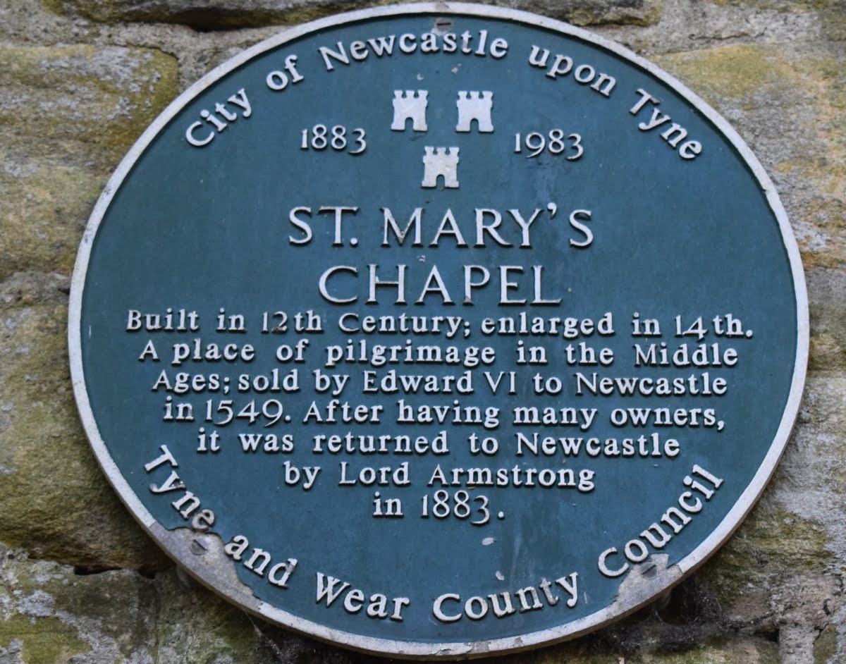
Cross Jesmond Dene Road opposite the Banqueting Hall and enter a small copse by the wooden gate provided. The copse, a small Dene formed by the course of a stream called the Moor Crook Letch, contains the remains of the Chapel of Our Lady of Jesmond or St. Mary's Chapel. The oldest church or chapel in Newcastle, this was probably built by the Grenville family, one-time Lords of Jesmond, early in the 12th Century, from which date are the remains of the pillars of the chancel arch.
The chapel is first mentioned in 1272 in an Assize Roll which records how five clerics helped a criminal escape from Newcastle Gaol - first to Jesmond Chapel and then to sanctuary at Tynemouth. Although the chapel was at one time in the possession of the Priors of Tynemouth, division of the manor between three sisters in 1333 led to confusion as to rights over the chapel and, at one time, three separate Chantries were maintained by their descendents; this confusion resulted in much scandal and damage, including stolen jewellery and chalices and in 1364, Edward III took claim. In 1549 the Mayor and Burgesses of Newcastle paid £144.13.4d to Edward VI to purchase the chapel and adjoining Hospice and in turn sold them to Sir Robert Brandling.
The Chapel has been a place of pilgrimage for centuries because of the divers miracles, reputed to have taken place among the sick who attended the Chapel and the neighbouring Holy Well. Even today there is an organised pilgrimage to the Chapel every year when a service is held in the ruins. Pilgrim street, in the centre of Newcastle, probably derives its name from being the route the pilgrims took on their journey to the Chapel. Following the Reformation and dissolution of the monasteries, the building thought to have been a hospital was rebuilt as a house, and the Chapel became a barn and stable; it passed through several hands until bought by Lord Armstrong who gifted it to the City.
Description courtesy of Friends of Jesmond Dene.
22nd September 2021


St. Mary's Well, which is Listed Grade II, is situated some 200 yards west of The Chapel and is traditionally considered a holy well, but it is probably no earlier than the 17th century. Its structure was remodelled in the 19th century. The well is located next to probable pilgrim's way leading to the nearby St. Mary's Chapel.
The visible remains include a well, a flagstone paved area enclosed by walls, and steps leading down to the well from the south. The well is circular in plan.
The well has been the subject of a partial excavation prior to restoration in 1982, which identified four phases of construction.
Phase one relates to the lower three courses of the well lining and the area of large flags immediately in front of the well opening and has been dated to the 17th century by brick fragments. The second phase saw the addition of a bath structure to the north west of the well by William Coulson in the early 18th century. This is not visible but will be preserved beneath the surface. The third phase, dated to the early 19th century, includes the enclosing of the well with the addition of the upper courses of the well-lining, capstone and door. Associated with this phase is the demolition of the bath, and the foundation courses of the west wall. The fourth phase is the erection of the east and west walls and the extension of the cobbled area to its present form.
Though the first historical reference to the well is in the 18th century and the present structure is believed to date from the 17th century, it is thought that there may have been a well of greater antiquity associated with St Mary's Chapel, which was a place of pilgrimage in the medieval period.
Source: Historic England.


31st October 2009


10th May 2007


More Information:
- Sitelines: St. Mary's Chapel
- Sitelines: Jesmond, St. Mary's Well
- Historic England: St. Mary's Chapel
- Historic England: St. Mary's Well
- Co-Curate: St. Mary's Chapel
- Historiette: St. Mary's Chapel
See my others photos around Jesmond Dene:
- Jesmond Dene
- Jesmond Dene, Banqueting Hall
- Jesmond Dene, Deep Dene House (Fishermans Lodge)
- Jesmond Dene, Pets Corner
- Jesmond Vale
- Jesmond, Jesmond Dene Nurseries
- Armstrong Bridge
- Armstrong Park
- Armstrong Park, The Shoe Tree
- Gosforth, South
- Heaton Park
- Heaton Park, House of Adam
- High Heaton
- High Heaton, Paddy Freemans Park
- Jesmond
- Sandyford
11 comments:
Thank you for the aerial photo of grosvenor road and St Mary Chapel. I lived at 55 Grosvenor Road until 1947 and often played in the chapel ruins. I think our house is just in the photo. Gave me a real nostaglia trip. We emigrated to New Zealand in 1947.
john ewen
You're welcome. The aerial photo is actually a map of what the area is like today so you can click and drag and zoom in for a closer look using the controls in the top left of the map.
Great pics-I've tried to find this place myself but had no luck. Is it near the banqueting hall?
Thanks. If the directions above don't work for you then come off Jesmond Dene Rd, walk along The Grove and turn right on to Reid Park Road and it's opposite the first house you see.
What do people think about the modern window, recently installed without permission?
Thanks NUFC-managed to find it on Google Maps there using your new directions. I was near Jesmond Dene House when I went looking for it, was way off heh heh. Look forward to visiting the chapel, thanks for the info :)
No problem, glad to have been of some help :)
Thanks very much for this. I too was looking for this near Jesmond Dene House today. I remember it from my chilhood (not quite so long ago as the first commenter's) and will be visiting it this week. Thanks.
You are most welcome.
I believe the council are about to start doing some kind of preservation work on the remains.
Congratulation,Can you explain the last pic?
It's also accessible from streets running down from Osbourne road Jesmond.
Post a Comment