The lower Ouseburn Valley through which Ouseburn river flows is home to a number of pubs (Free Trade - right at the confluence with the Tyne with good view of the bridges looking upriver, The Tyne, the Cumberland Arms, The Ship Inn, Tanners and The Cluny) known locally in the Newcastle area for live music and real ale. It is also a hub for the arts and creative industries, including the Biscuit Factory (open gallery), the Mushroom Works (open first weekend of the month), Testhouse 5 (appointment only), North Grange Glass (stained glass gallery and cafe), 36 Lime Street and Cobalt Studios.
Whilst the area was the cradle of the Industrial Revolution in Newcastle and was once home to many thriving (and very dirty) heavy crafts industries, it fell into disuse and dereliction by the mid-twentieth century. The current incarnation of the Valley as a cultural regeneration hotspot was initiated by the Ouseburn Trust, in partnership with the local authority, in 1996. The Trust remains a landlord and developer in the Ouseburn, and seeks to involve people in the heritage and regeneration of the area through its programme of free walks, talks and volunteering activities.
Text adapted from Wikipedia.
5th March 2012

Taken from Lime Street looking East.

Taken from Ouse Street looking East.
6th January 2012

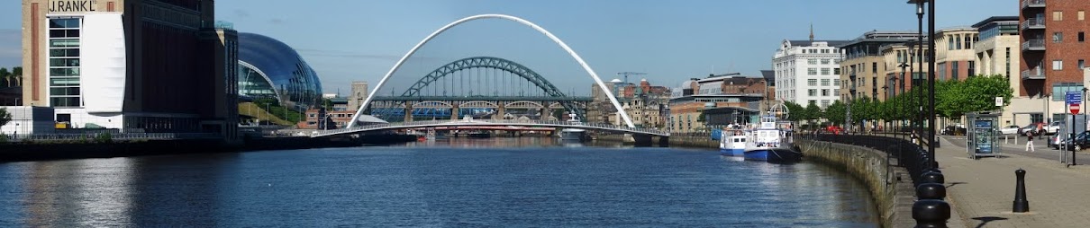
Looking East where The Ouseburn meets the River Tyne.
22nd November 2011
.jpg)
.jpg)
.jpg)
.jpg)
.jpg)
.JPG)
The Ouseburn.
.jpg)
Seven Stories.
A large flour mill designed by Gibson Kyle and built for Proctor and Sons, who at that time owned the adjoining former flax mill, built 1873-4. By 1896 the mill was owned by a family of miller's named Leethams, who also owned the adjacent property. The name Leethams can still be seen painted onto the gable end of the building. Until the 1920s there was an internal walkway through the two buildings. Leethams left 1916 and various small businesses utilised the building.
From the 1940s to 1980s the building was owned by a farmer's co-operative, Farmway, and used to grind cattle feed. During the 1970s it was sold to the Revolutionary Workers Party to house a printing press. Basic remedial work was carried out on what had become a derelict building. Now converted into the Centre for Children's Books [2004]. Brick with ashlar dressings and rear basement to river.
Welsh slate roof. 4 storeys, 3 bays and 2 bays set back at left. 3 high vehicle entrances have segmental brick arches on 2 cast iron columns; outer brick piers have cast-iron fenders and stone impost blocks; iron cladding to brick springers over central columns. The maker's mark (Toward of St Lawrence) can be seen on the cast iron columns. Within the arches are double doors under wood lintels. Rear elevation to Ouseburn has central gabled hoist.
Grade 2 Listed. Source: Sitelines.
.jpg)
Lime Street, No. 36, Flax Mill (Cluny Warehouse).
Built as a flax mill in 1848 on the site of an earlier corn mill, to the design of John Dobson for the firm of Plummer and Cooke, who previously owned the flax mill on the adjacent site which became Northumberland Lead Works. Flax was used to make linen and sail cloth.
Originally steam powered the adjacent freestanding, recently restored chimney forms part of the original Dobson complex. Its use as a flax mill was short. In 1866 it was bought by Proctor and Sons and converted to a flour mill. The building was extended in the mid 1870s when two brick warehouses were constructed - one for flour, the other for grain. The complex is shown on Ordnance Survey second edition as "Northumberland Mills".
Then taken over by Henry Leetham and Sons in 1900. A Miss Carr apparently lived in the garden house next to the big chimney and was employed by Leethams to test each batch of flour by baking small loaves of bread in her oven. The flour mill stood empty for many years until it was taken over by McPhersons Wine and Spirit Merchants in the 1920s, who stored bonded whiskey under the brand name of Cluny.
Now internally divided, it has a variety of users, mainly craftspersons or artists and a café bar. Sandstone ashlar, later brick additions and attic storey date to 1870s, Welsh slate roof. The road between mill and chimney is at a much higher level than the internal cobbled yard into which the former coal shoots opened. One of the shoots retains its original metal shutter.
Grade 2 Listed. Source: Sitelines.
4th October 2011

The River Ouseburn.
23rd August 2011
.jpg)
The Ouseburn Barrage.
.jpg)
.jpg)
Maling Street.
24th July 2011
.jpg)
Lime Street, Nos. 1-5 (Coal Merchants).
Detached three-storey building on corner of Lime Street and Cut Bank. This was the coal depot of J.T. Potts. The Potts family acquired the property in 1898. Trade directories before this date list the property as "Montague Coal Depot" under the ownership of S. Wood.
After 1898 the business is listed as T. Potts and Co, Coal Merchants. It was still in the Potts family in 1929. The offices were on the ground floor, with residential rooms above. Coal was stored in the yard to the rear. Access into the yard by coal wagons was through a passageway shown on the Ordnance Survey second edition.
Source: Sitelines.
.jpg)
17th May 2011
.jpg)
16th February 2011

Cut Bank, glasswork flues.
These remains of a brick furnace reflect the importance of the Ouseburn glass industry. More accurately they are five flue arches belonging to the former Liddell-Henzell Bottle Works, which was founded in the 19th Century. The works were situated next to the Cut Bank Bridge over the Ouseburn.
Source: Sitelines.
29th November 2010

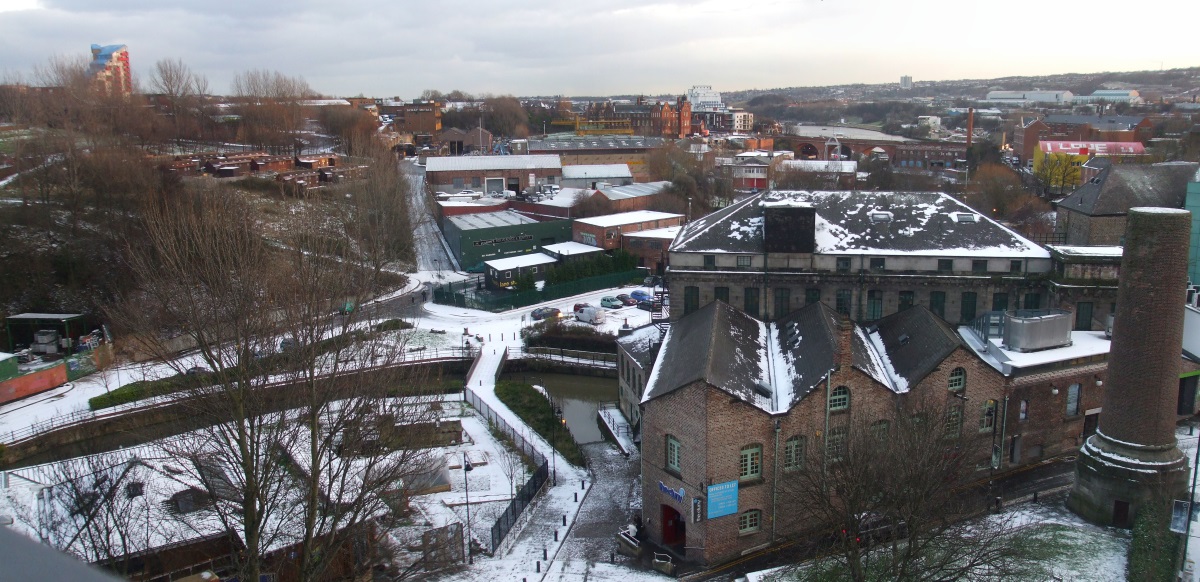
Looking SE from Byker Bridge.


A snowy Ouseburn Valley.
23rd April 2010

Ouseburn Farm.

Now the site of Malings housing development.
r.jpg)
Ouseburn Bridges
The Metro bridge and The Ouseburn Viaduct (East Coast mainline train).
16th April 2010
r.jpg)
36 Lime Street(The Cluny Warehouse).
r.jpg)
The River Ouseburn.
r.jpg "April 2010")
The Ouseburn Viaduct and The Metro Bridge.
27th March 2010

Glasshouse Bridge and the old Toffee Factory.
18th December 2009


r.jpg "December 2009")
r.jpg "December 2009")


Snowy Ouseburn Valley.
27th November 2009

View from across the River Tyne.
29th October 2009


Taken from The Baltic in Gateshead.
19th July 2009
r.jpg "Ouseburn Festival 2009")
r.jpg "Ouseburn Festival 2009")
r.jpg "Ouseburn Festival 2009")
r.jpg "Ouseburn Festival 2009")
r.jpg "Ouseburn Festival 2009")
r.jpg "Ouseburn Festival 2009")


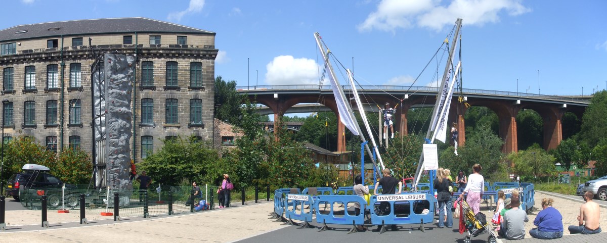
Ouseburn Festival.

Derelict factory near Ballast Hills.
23rd June 2009

Taken on Horatio Street looking east along City Road.

Horatio Street.

Ouseburn Farm.

The view from the Free Trade pub.
r.jpg "36 Lime Street(The Cluny Warehouse)")
36 Lime Street (The Cluny Warehouse).
r.jpg "Ouseburn")
r.jpg "Ouseburn")
r.jpg)
r.jpg)
The River Ouseburn.
16th June 2009
r.jpg "36 Lime Street(The Cluny Warehouse)")
36 Lime Street(The Cluny Warehouse).
25th May 2009

Taken on Glasshouse Bridge.
8th January 2009

Looking over the valley from the western side.
3rd February 2009
r.jpg "February 2009")
Foundry Lane.
3rd February 2009

Foundry Lane steps leading to The Cumberland.
2nd February 2009
r.jpg "February 2009")
r.jpg "February 2009")
r.jpg "February 2009")
r.jpg "February 2009")
r.jpg "February 2009")
r.jpg "February 2009")
Snowy Ouseburn Valley.
5th January 2009
r.jpg "Ford Street - February 2009")
Ford Street.
19th November 2008
r.jpg "The River Ouseburn")
The River Ouseburn.
r.jpg "November 2008")
Ford Street.
22nd October 2008
r.jpg "October 2008")
r.jpg "October 2008")
Ford Street.
r.jpg "October 2008")
St. Lawrence Road, Free Trade Inn.
The former beerhouse probably opened shortly after the introduction of the 1830 Beer Act. Bought by Henry Davidson of the White Lion Brewery in 1888. Rebuilt in 1896 to designs by Oswald and Son. Their original design had two large decorative gables in Queen Anne revival style with ball finials and hooded canopy over the door.
Inside the bar had a V-shaped counter to echo the shape of the building. There was a club room upstairs. Henry Davidson opted for a cheaper design which increased the size of the tenant's accomodation and replaced the proposed club room with bedrooms.
The façade hardly had any decoration apart from facings round the windows and a parapet inscribed with the name Free Trade.
In 1899 Matthew Wood, brewer from South Shields bought it. In 1911 there were structural alterations. The tenant's kitchen became a parlour, the bar counter was extended and the family room became part of the main bar. In 1919 the Free Trade became a Newcastle Breweries pub. In 1937 more internal partitions were removed.
It almost closed in 1947 when Newcastle Breweries applied to transfer the licence to a new pub to be built in Sackville Road. The Free Trade was not granted a full publican's licence until 1963. It is still a free house. Little of the original interior survives apart from the basic form of the bar counter and part of the back bar fitting.
Source: Sitelines.
r.jpg "October 2008")
Byker Bank.
17th October 2008

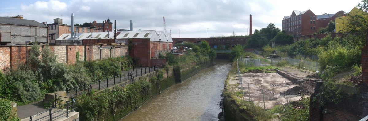
The River Ouseburn.
16th October 2008

Steenbergs Yard.

Byker Bank.
15th September 2008
r.jpg "September 2008")
The River Ouseburn.
8th September 2008
Looking South along the undeveloped stretch of the river from Byker Bank.
r.jpg "The Tanners")
The Tanners Arms.
r.jpg "Glasshouse Bridge")
Glasshouse Bridge.
The site of the Glasshouse Bridge, at the confluence of the Ouseburn and the Tyne has long been a popular point at which to cross the Ouseburn Valley; there was a wooden bridge at a lower level as early as 1619.
The 6-arch brick road bridge was built in 1878 and provided easier access to the industrial sites along the river bank. The name is derived from the former Glass Houses that stood on the eastern side of the Ouseburn Valley. Originally the bridge was known as New Glasshouse Bridge to differentiate it from the older Lower Glasshouse Bridge, which was demolished in 1908.
Source: Sitelines.
r.jpg "Crawfords Bridge")
r.jpg "Crawfords Bridge")
Crawford's Bridge.
The oldest of the surviving bridges crossing the lower Ouseburn. Built early to mid 18th century of coursed, squared sandstone. The name derives from Thomas Crawford who owned a number of properties in the area in the early C19.
Coursed squared sandstone. Segmental arch recessed under chamfered abutment; parapet courses follow slope of road, high at centre. Chamfered coping to parapet ending in low piers, with pyramidal coping to that at south-west, and continuous stretch of wall about three metres at north-east. Stone drains from road surface protrude through north-east and south-west faces. Mason's mark - diagonal cross in square - above road at centre of west parapet, O.S. bench mark above road at centre of east parapet.
Source: Sitelines.
29th July 2008

r.jpg "Seven Stories, The Centre for Children's Books")
r.jpg "Seven Stories, The Centre for Children's Books")
Seven Stories, The Centre for Children's Books on Lime Street.
20th July 2008
r.jpg "Ouseburn Festival 2008")
r.jpg "Ouseburn Festival 2008")
r.jpg "Ouseburn Festival 2008")
r.jpg "Ouseburn Festival 2008")
r.jpg "Ouseburn Festival 2008")
r.jpg "Ouseburn Festival 2008")
r.jpg "Ouseburn Festival 2008")
r.jpg "Ouseburn Festival 2008")
r.jpg "Ouseburn Festival 2008")
r.jpg "Ouseburn Festival 2008")
r.jpg "Ouseburn Festival 2008")
r.jpg "Ouseburn Festival 2008")
r.jpg "Ouseburn Festival 2008")
r.jpg "Ouseburn Festival 2008")
Ouseburn Festival.
14th July 2008

Looking over the valley from the western side.

The River Ouseburn meets the River Tyne.

Looking over the valley from the western side.
4th July 2008
")
36 Lime Street (The Cluny Warehouse).


The River Ouseburn meets the River Tyne.


The River Ouseburn.

r.jpg "Glasshouse Bridge")
Glasshouse Bridge.
29th June 2008

Cut Bank.

36 Lime Street (The Cluny Warehouse).
23rd June 2008

The Ouseburn Viaduct and the newer Metro bridge.
10th June 2008

Stepney Bank Stables on Lime Street.
")
")
")
36 Lime Street (The Cluny Warehouse).
r.jpg "Seven Stories, The Centre for Children's Books")
Seven Stories, The Centre for Children's Books on Lime Street.
18th May 2008

Derelict factory near Ballast Hills.
17th October 2007

The River Ouseburn.
10th October 2007

36 Lime Street(The Cluny Warehouse).

Glasshouse Bridge.
21st July 2007
r.jpg "Ouseburn Festival")

r.jpg "Ouseburn Festival")
r.jpg "Ouseburn Festival")
r.jpg "Ouseburn Festival")
r.jpg "Ouseburn Festival")
r.jpg "Ouseburn Festival")
r.jpg "Ouseburn Festival")
r.jpg "Ouseburn Festival")
r.jpg "Ouseburn Festival")
r.jpg "Ouseburn Festival")
r.jpg "Ouseburn Festival")
Ouseburn Festival.
3rd May 2007
r.jpg "May 2007")
Ouseburn Farm.
r.jpg "Ouseburn bridges")
r.jpg "Ouseburn bridges")
r.jpg "Ouseburn bridges")
r.jpg "Ouseburn bridges")
Byker Metro Bridge.
Byker Metro Bridge (also known as Byker Viaduct) was constructed 1978-1979 and was purpose built for the Tyne and Wear Metro system, which opened in 1980. The viaduct carries the metro over Ouseburn Valley between Newcastle city centre and Byker.
Source: Co-Curate.
r.jpg "Ouseburn bridges")
The Ouseburn Viaduct.
Ouseburn Viaduct is the sister viaduct of another at Willington. It is a wrought iron reconstruction of the original laminated timber structure, built by John Green in 1837-9. It is 918 feet (280 metres) long, with four stone approach arches and five main arches, carrying the railway 108 feet (33 metresetres) above the Ouseburn. The stone piers carried the original timber structure and were probably designed to be reused when the timber was replaced.
Grade 2 Listed. Source: Sitelines.
2nd March 2007

Lime Street.
r.jpg "36 Lime Street(The Cluny Warehouse)")
36 Lime Street(The Cluny Warehouse).
r.jpg "The Ship Inn")
Stepney Bank, Ship Inn
The Ship Inn is a popular and attractive traditional working class pub located in the heart of the Ouseburn, lying beneath Byker Bridge. In the past it was popular with the local abattoir workers. The building was originally part of a terrace in Stepney Bank which was destroyed during the 1930s. It has been designed relatively simply. It has two storeys and an attic above with two dormers. The ground floor has large windows with painted stone lintels and sills. The façade is brick and the west side has been rendered white. Also on the side is a single storey modern garage extension.
Source: Sitelines.
r.jpg "Ouseburn bridges")
r.jpg "Ouseburn bridges")
Byker Metro Bridge.
r.jpg "Ouseburn bridges")
Byker Road Bridge.
Constructed in 1878 to overcome the need to descend and ascend the steep sides of the Lower Ouseburn Valley. 1878 for pedestrians, 1879 for raod traffic. A toll was charged for its use until 1895. Cost £50,000 to build. Originally a toll bridge. Purchased by City Council in 1890 for £107,500. Between 1878 and 1895 a toll of half a penny was charged for use of the brick bridge. Toll lifted 1895. In 1899 the bridge was widened from its original width of 9m to 15m.
Source: Sitelines.
r.jpg "Ouseburn bridges")
r.jpg "Ouseburn bridges")
r.jpg "Ouseburn bridges")
Ouseburn Bridges.
1st January 2007
r.jpg "The Free Trade")
r.jpg "The Free Trade")
The Free Trade.
14th July 2006

Horatio St, Blenkinsopp-Coulson Drinking Fountain.
Drinking fountain and portrait bust. 1914; signed Alexis Rudier and bust dated 1912. Sandstone, pink granite and bronze. Wide stone base; granite plinth and basins; sandstone pedestal with long inscription commemorating W.L. Blenkinsopp Coulson and his efforts to help the weak and defenceless 'among mankind and in the animal world'.
Larger-than-life bust has drapery wrapping round pedestal. Has two fountain bowls - one for humans, one for animals. The fountain originally stood in Percy Street before being moved to the Haymarket then in 1950 to its present site. Statue to William Lisle Blenkinsopp-Coulson 1841-1911. Erected by public subscription. Bronze bust by A. Rechbers and cast by Alexis Rudier, Paris, surmounts a sandstone pedestal. There are two new rather crudely carved animal heads. The originals will have faucets discharging from the mouths of the beasts. There is now no water supply.
Grade 2 Listed. Source: Sitelines.

Byker Metro Bridge.
13th July 2006
")
36 Lime Street(The Cluny Warehouse).
26th June 2006

The River Ouseburn.
19th June 2006

The River Ouseburn.

Seven Stories, The Centre for Children's Books.

Byker Metro Bridge.
18th May 2006

Maling Street, The Tyne Public House (Ship Tavern).
The Tyne public house, originally known as the Ship Tavern, has been an important part of the Ouseburn since the 19th Century. The Ship Tavern was opened in 1850 only to be destroyed by fire before 1895, when the pub was rebuilt as it stands today. This two storey building has decorated sandstone pillars and arched ground floor windows set in a brick face. The windows have leaded stained glass upper panes, and lower panes engraved ‘Ship Tavern’. The pub is known locally as the ‘Bottom Ship’.
Source: Sitelines.
27th April 2006

The Ouseburn Viaduct.
15th February 2006

Maling Street, The Tyne Public House.
8th February 2006

The River Ouseburn.

James Place Street, Cumberland Arms.
The Cumberland Arms is located on James Place Street in Ouseburn, Byker (rear to Back Stephen Street) and was first licensed as a beer house in 1862. The present building dates from 1899, rebuilt following collapse of the earlier building during renovations. A Mr James Cackett was engaged to make internal alterations - increasing the bar area and adding a new façade. Nos. 2 and 3 James Place were incorporated into the public house. This plan survives largely unchanged today.
The pub was once owned by 'Jocker' Wood (1854 - 1937), a popular sportsman and publican. In 1919 the pub was purchased by Wilkinson's Pinestreet Brewery of Elswick, and underwent alterations in 1935.
Source: Sitelines.
")
36 Lime Street, The Cluny Warehouse.

Byker Bridge.
24th January 2006

The Ship Inn.

Byker Bridge.
17th January 2006

Lime Street.

Byker Metro Bridge.

Byker Bridge.
16th January 2006

Glasshouse Bridge.
16th December 2005


The Ouseburn Viaduct.


Byker Bridge.


Byker Metro Bridge.


Seven Stories, The Centre for Children's Books.


The Cumberland Arms.


The Ouseburn.

Crawford's Bridge.
More Information:
- Ouseburn Trust Homepage
- Culture 24 - Ouseburn Valley Heritage Chronology
- Wikipedia - Ouseburn
- Wikipedia - Ouseburn Valley
- Ouseburn Trust - Victoria Tunnel
- Stepney Bank Stables
- Historic England - Lower Ouseburn Valley, Newcastle
- Co-Curate - Ouseburn (river)
- Co-Curate - Ouseburn Valley
- Co-Curate - Ouseburn Historic Timeline
- Sitelines - Lower Ouseburn Valley Conservation Area
- Sitelines - Ouseburn, waymarkers
- Sitelines - Cumberland Arms, 'Seats with a View'
- Sitelines - Ford Street, Maling Pottery packing house
- Sitelines - Ford Street, Maling's Ford A Pottery
- Sitelines - Ford Street, Maling's Ford A Pottery, tunnel
- Sitelines - Ouseburn Culvert
- Sitelines - Ouseburn Lead Works
See my other photos around Ouseburn:
- Ouseburn - 2014 to 2018
- Ouseburn - 2020 to 2023
- Ouseburn - 2024
- Ouseburn Schools and Ballast Hills Burial Ground
- Ouseburn - Lower Steenberg’s Yard Construction
- Ouseburn - Street Art and Graffiti
- Ouseburn - The Malings
- Ouseburn - Toffee Factory
- Ouseburn - Victoria Tunnel
- Ouseburn Barrage
- Ouseburn Farm
- Ouseburn Quays Construction
No comments:
Post a Comment