A pleasant 3 mile walk from Woolsington to North Walbottle passing through Callerton Village on mostly flat paths and tracks with a few short stretches on minor roads.
Good footwear is essential as a short part of the walk near the beginning can get very muddy in poor weather.
I've done this walk a few times over the years and this page features a mix of photos taken in 2009 and 2018. An easy way to tell the difference between the photos is that the weather was lovely in 2018 and not so in 2009.
Route Map
Starting off at Ponteland Road in Woolsington turn down Green Lane passing Sandra's Village Tea Rooms on your right.
You quickly arrive at a sign saying 'Public Bridleway Low Newbiggin 2/3'.
Join the Bridleway and cross the Metro lines carefully following the instructions on the nearby sign.


Shortly after cross the footbridge over the airport road.

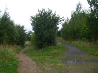
Around 50 yards after the footbridge take the path to your right almost doubling back on yourself.
The right side of the picture below shows where you came from and the left side is the path you follow.

Follow the path as it initially runs alongside the previously mentioned airport road on your right.


The path soon bears left away from the road.
This area forms part of the old Butterlaw coal workings.


After a while the path exits onto Whorlton Lane.
Turn right and follow the single track road passing Butterlaw Farm on your right.


At the T-junction turn left into Callerton Village.


Follow the road through Callerton passing the Poachers Cottage on your right.


Soon enough you arrive at Stamfordham Road.
Turn left and follow the short footpath alongside the road past the fantastic bus stop.


Cross the road and join the footpath opposite.

Walk up the path with the hedgerow on you right.

Once at the metal barriers turn right going through them and joining a broad track.


Eventually the track ends at North Walbottle Road which ends this walk.
See my other photos around Woolsington:


No comments:
Post a Comment