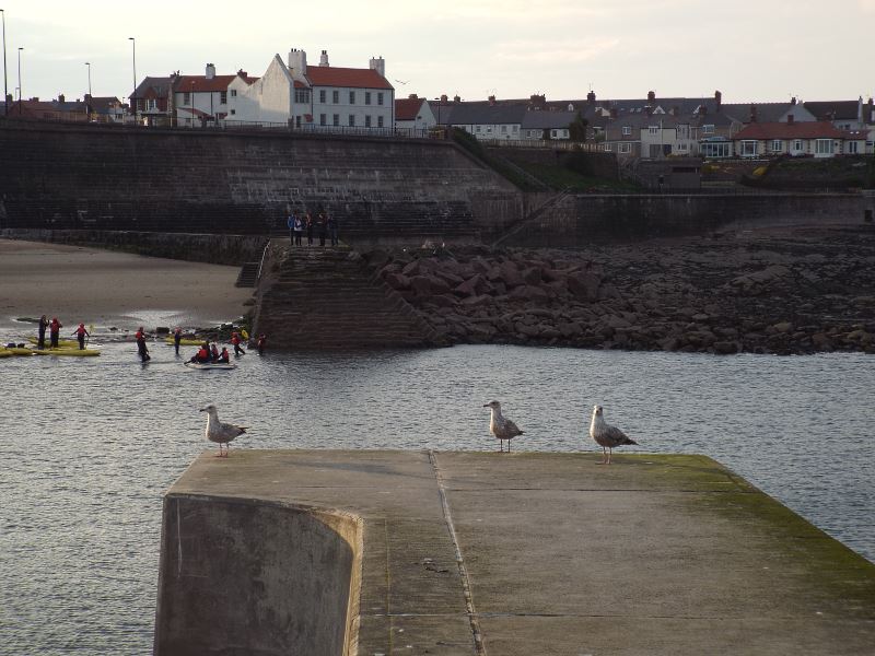
Cullercoats is part of the North Tyneside conurbation, sitting between Tynemouth and Whitley Bay. There is a semi-circular sandy beach with cliffs and caves, and the village is a popular destination for day-trippers. The name is thought to derive from Dove (or Culver) Cotes.
Historically the village depended on fishing; there was also local coal mining in so-called bell pits. The coal was used to fire salt pans (now long gone) on the field now known as the boat field. As a port, Cullercoats was used to export both salt and coal. However, the salt industry declined and the growth of the railways led to coal shipments being relocated to better harbours. This left fishing as the main industry and two piers were built on either side of the harbour to provide shelter for the many open top fishing vessels, or cobles, launched from the harbour.
Text courtesy of Wikipedia.
7th July 2023


Cullercoats Bay, RNLI Lifeboat Station.
The Cullercoats Volunteer Life Brigade was founded in 1865. On the 20th November 1894 Captain N.H. Foote inspected the lifeboat house. It had been built for the 'Percy' in 1852. Foote found it 'too narrow and confined, in fact very old fashioned'. He suggested that the Co-operative Wholesale Society, who had provided the lifeboat, might be persuaded to update the building. Mr Leeson the secretary made the application, which was successful. The old lifeboat house was demolished and a new one built to designs by Oliver and Leeson by CWS workmen. The formal opening was on 8th August 1896, with a procession and an exhibition at the Plaza.
Red brick with sandstone ashlar dressings; timber cladding and barge boards to the upper parts and a pitched slate roof. Two-storey gabled boathouse with wide replacement double doors, with timber cladding and some original square ventilation grilles above. Four vertical rectangular grilles have been replaced with glazing to light the inserted first floor room. Decorative barge boards bear an inscription in large wooden script based on Psalm 107:6: 'So when they cry unto me in their trouble. He delivereth them out of their distress and bringeth them unto the ha ven where they would be'.
The left return has a pair of rectangular windows and a central projecting tower with with similar windows lighting the ground floor. The tower has a crow-stepped left side and a crenellated top surmounted by an open timber belfry with a cupola roof and decorative finial. The bell is still in-situ.
The modern two-bay extension to the right is not of special interest and is not included in the listing.
Interior - wainscoting with exposed red brick walls above. Narrow band of red and white glazed brick. An inset stone foundation stone is set into the north west gable wall. The north east wall has a pair of original camber-headed windows fitted with small panes. The timber roof has three large trusses.
Source: Sitelines.
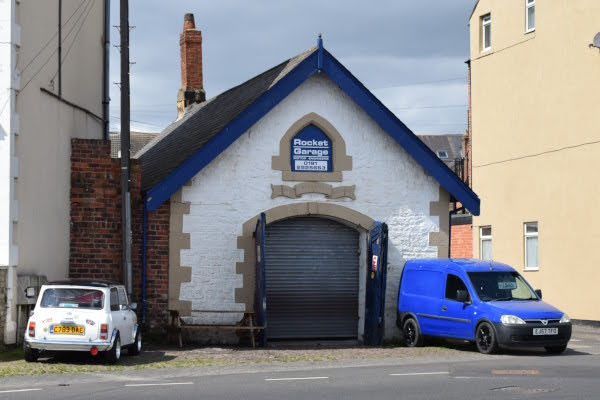
John Street, Rocket Garage.
Life Brigade Apparatus House for Cullercoats Life Brigade, now a private dwelling. Dated 1867 above door. Painted snecked stone with ashlar dressings and quoins; graduated slate roof and brick chimney. One storey. Double boarded door in elliptical- headed keyed arch and alternate-block jambs. Inscribed stone scroll above - LIFE BRIGADE HOUSE/1867. Small chamfered pointed-arched niche above. Bargeboards with finials.
Grade 2 Listed. Source: Sitelines.
1st September 2022


Cullercoats Bay.

Cullercoats Bay, Dove Marine Laboratory.


Cullercoats Bay, RNLI Lifeboat Station.


Life Brigade Watch House, Victoria Crescent, Cullercoats.
This was designed by Frank West Rich, who designed Turnbull's Warehouse and Bolbec Hall (amongst other buildings). The Cullercoats Life Brigade, the second to be formed (after Tynemouth), was formed after 1864 and the Watch House constructed between 1877 and 1879. Built of roughly-squared sandstone with rock-faced quoins and dressings, a wooden verandah and tiled roof. Shingled belfry with balustrade. One storey. Boarded door under catslide roof. One stone-mullioned square-headed window under gable. Casements with glazing bars in back verandah. Clock turret has tall octagonal roof.
Grade 2 Listed. Source: Sitelines.
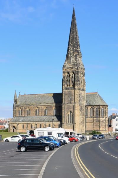


Cullercoats, Church of St. George.
Built between 1882 and 1884 at a cost of around £30,000 by J.L. Pearson for 6th Duke of Northumberland as a memorial to his father George Percy, the fifth Duke of Northumberland. The church was designed in medieval style and has a 180 feet spire.
Squared sandstone with ashlar dressings and plinth. Slate roof with stone gable copings. Early English style.
Interior - ashlar with groined vaulting. Nave arcades on round piers with moulded capitals. Terrazo and marble floor in chancel. Stone communion rail and pulpit. Stanhope marble base to square font on on pedestal. Art nouveau copper light fittings in aisles. East pier of south arcade has brasss plate commemorating laying of foundation stone 4th August 1882. Only local example of J.C. Pearson's work.
Grade 1 Listed. Source: Sitelines.

Cullercoats, Church of St. George, war memorial.
World War One crucifix memorial outside St. George's Church. Unveiled by Lord Armstrong 1921. Rededicated by the Duke of Northumberland in 1989 with a new bronze plaque.
Source: Sitelines.


Cullercoats, Beverley Terrace, Adamson Fountain.
Memorial drinking fountain. Circa 1888. Erected by friends of B.J.H. Adamson, site given by Duke of Northumberland. Sandstone with marble panels; cast iron lion masks. Two steps to octagonal plinth with marble inlaid panels beneath cornice. Bowl in top of plinth receives water from four lion masks.
Inscription on east panel: ERECTED BY A FEW FRIENDS IN MEMORY OF BRIAN JOHN HUTHWAITE ADAMSON, LIEUT. R.N. COMMANDING H.M.S. WASP WHICH SAILED FROM SINGAPORE SEPTEMBER 10 1887 AND WAS NEVER HEARD OF AFTER. THE SITE WAS GIVEN FOR THIS MEMORIAL BY HIS GRACE THE DUKE OF NORTHUMBERLAND. Carved decoration of dolphin, shell and ribbon patterns. Shields with mottoes on obelisk.
Grade 2 Listed. Source: Sitelines.


Cullercoats, Beverley Terrace.


Cullercoats, Victoria Crescent, Cliff House.
House, 1768, with C19 alterations. It was built by Captain Thomas Armstrong, a Customs Officer and originally known as "Bank Top House". Armstrong was the commander of His Majesty's Cutter "Bridlington" a customs vessel which patrolled the seas from Newcastle to Sunderland.
The house has a huge cellar with wrought iron bars separating prison type cells. By 1771 the cellar was being used to store smuggled goods and the smugglers! Clearly Armstrong paid for this grand Georgian house through his life of crime! Armstrong was charged and convicted of allowing smugglers to escape. In 1776 Armstrong was dismissed from his job when he allowed two notorious smugglers to escape.
There is a secret passage in the house accessed by a trapdoor in the study which leads down through the cliff and onto the beach. The entrance on the beach is now blocked by the sea defence walls which were built in the 1960s.
The house was sold to Harry Hewitson in 1837. The house was merged with an adjoining cottage dating to 1720 and another cottage of 1840. In 1846 Robert Arkwright bought the house for his wife Fanny. The Duke of Devonshire was a frequent visitor to Cliff House. His bedroom at Cliff House is said to be similar to bedrooms at his ancestral home at Chatsworth, Derbshire, with panelling and bedposts made from narwhal tusks.
Grade 2 Listed. Source: Sitelines.

Front Street, Queen's Head Inn.
There has been an inn on this site since 1813. By 1828 it had been refurbished by William Thompson. The first recorded publican was Margaret Challoner in 1828. The pub was modernised between the wars. It suffered bomb damage in April and May 1941. The windows have since been replaced.
Source: Sitelines.


Cullercoats, Brown's Point, Radio Telegraph (Y) Station.
A timber shed and radio station masts were built here in 1906-7 by the Amalgamated Radio Telegraph Company, who had formed in 1906 through the merger of the British De Forest Wireless Telegraph Syndicate (Lord Armstrong was an owner) and Poulsen and Pedersen's Danish wireless company. The station was used experimentally to send and receive messages from Denmark. The Amalgamated Radio Telegraph Company collapsed in 1907 when Lord Armstrong became bankrupt, and the site was sold to the Poulsen Arc Company of Debmark, who were forced to operate in Britain by the restrictive Danish broadcasting laws.
In 1912 the site was taken over by the GPO, who used Marconi equipment, which resulted in the construction of new antennae, apparently supervised by Guglielmo Marconi himself. The Admiralty took over the running of the station during WW1 to use it as a base for intercepting German radio traffic.
In 1916 a new brick building replaced the original timber shed. During the 1920s, when radio technology continued to improve, the arc-gap equipment was replaced by valve transmitters. A second building was constructed in 1926 to cater for the increase in staffing.
Little is known about the use of the site in WW2. The site was bombed and the staff were enlisted into the Home Guard. In 1951 new transmitters were installed and new aerials, although the use of the aerials was short-lived as they became unstable and were moved to Hartley in the 1950s. Masts did survive on the site into the 1990s however - the site continued in use as the receiver site for the new aerials, until the need for 24 hour emergency watch for distress calls in morse was discontinued in 1998. It continued as part of the radiotelephony Coast Radio Station service until 1999.
Grade 2 Listed. Source: Sitelines.


Browns Point.
23rd February 2017


Storm Doris.
Thankfully we in the North East missed the worst of Storm Doris but it was quite rough.
17th June 2016


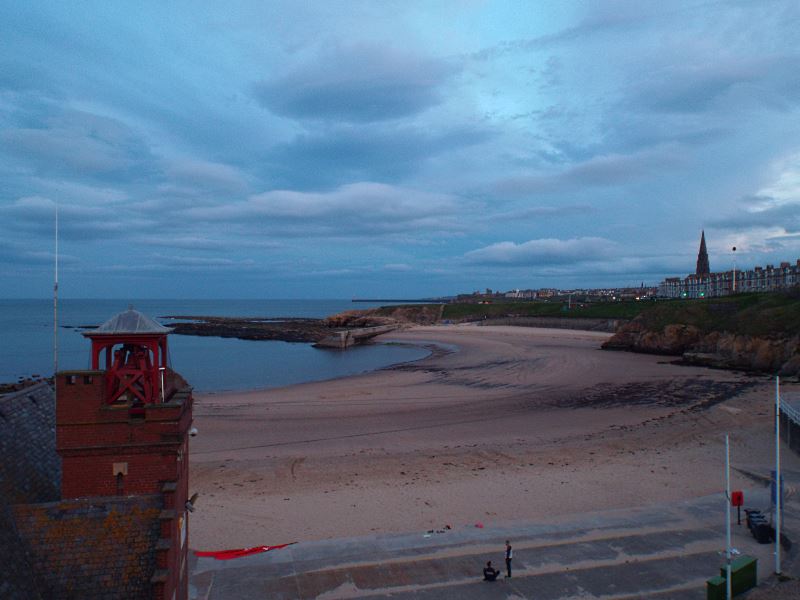


Cullercoats Beach and Harbour at dawn.
30th September 2014


6th June 2014
.jpg)
Cliff House.
House, and attached former cottage. Circa 1768 with early C19 alterations, restored late C20. Painted render with plinth and quoins, pantiled roof with flat stone gable copings. Painted brick chimney at right, painted rendered at left. Irregular plan.
Main sea front: 2 storeys, 5 windows all sashes with glazing bars; sill bands; one-bay left wing has double door in pantiled lean-to porch under tripartite sash. Right entrance front of 2 storeys, 3 windows and extension of one storey and attic, one bay, has central 6-panel door in flat classical doorcase; sash windows with projecting stone sills and glazing bars.
INTERIOR, has some original C18 features and much early C19 alteration. Entrance hall has an C18 fire-surround with later mirrored overmantel, C18 cupboards and coving. Former customs office to right has original cupboards and strong room with early C19 marble fireplace. Main reception room has shuttered windows, boarded dado panelling and another marble fireplace. Beyond smaller room has C18 dentilated coving, boarded panelling and C18 shutters to windows.
Former courtyard now contains fine large early C19 staircase with stick balusters and mahogany handrail, the upper floor doors have fine door surrounds with fluting and patera. Main upper room has C18 shutters and later alcoves. Small room over hall has C18 fire-surround and cupboards. Panelled room has C18 doors and fireplace with C19 overmantel and panelling.
Back staircase has stick balusters and moulded handrail. Former rear yard now enclosed first-floor grotto or aviary. Cellar has iron-barred cell, possibly bonded store, with neck manacles attached. Historical note: bought in 1846 by Robert Arkwright, son of Sir Richard, for his wife who was daughter of the actor Stephen Kemble.
Grade 2 Listed. Source: Historic England.
.jpg)
Cullercoats Lifeboat Station.
The first lifeboat in Cullercoats was funded by the Duke of Northumberland. This became operational in 1852 following the establishment of The Royal National Lifeboat Institution (RNLI) charity in 1824. In 1896 the current boathouse was built, funded by the Co-operative Wholesale Society and designed by architects Oliver and Leeson of Newcastle.The building is Grade II listed. The lifeboat at Cullercoats has launched more than 720 times and saved well over 840 lives.
Source: Co-Curate.
.jpg)
.jpg)


Cullercoats Beach and Harbour.
15th May 2014


Cullercoats, Brown's Point, Radio Telegraph (Y) Station.

3rd April 2013
.jpg)

Church of St George.
.jpg)
.jpg)
.jpg)
.jpg)
.jpg)
.jpg)


Cullercoats Beach and Harbour.
August 2009

r.jpg "Cullercoats Beach")
r.jpg "Cullercoats Beach")
r.jpg "Cullercoats Beach")
r.jpg "Cullercoats Beach")
r.jpg "Cullercoats Beach")
Cullercoats Beach and Harbour.
June 2009


Cullercoats Beach and Harbour.

Cullercoats, Brown's Point, Radio Telegraph (Y) Station.

Victoria Crescent.


Cullercoats Watch Club House.
Look-out house, now club. 1877-79 by F. W. Rich for Cullercoats Life Brigade. Roughly squared sandstone with rock-faced quoins and dressings; wood verandah; plain-tiled roof. Shingled belfry with balustrade.
One-storey, one-bay gable end to street and set-back corner porch at left; rear polygonal. Boarded door in porch under catslide roof; 4-x 3-light stone-mullioned square-headed window under gable has 2 stone and one wood transoms. Casements with glazing bars in back verandah which has turned posts supporting catslide hipped roof. Clock turret, in right return, has tall octagonal roof.
Historical note: Cullercoats Life Brigade was the second to be formed, immediately after that at Tynemouth on 5th December 1864.
Grade 2 Listed. Source: Historic England.


Cullercoats Metro Station.
A station at Cullercoats, on the North Eastern Railway Newcastle, Tynemouth and Newcastle line. Opened 7th July 1882. Now metro station. The station designed by William Bell (architect to the North Eastern Railway Co. from 1877 to 1914) and opened July 7th 1882 and has been a Metro station since August 11th 1980. This station was built with salvaged materials from a former station. A feature of this station is a well-preserved wooden footbridge and indeed, the whole station is considered one of the least altered local stations, despite some feature deterioration as a result of the Metro presence.
Source: Sitelines.


Cullercoats Radio Station.


Cullercoats Lifeboat Station.


Cliff House.

The Queens Head, Front Street.

Station Road.

Eleanor Street.

Boatyard, Victoria Crescent.

Bank Top.
15th April 2007

Cullercoats Watch Club House.

Adamson Memorial Drinking Fountain.
Memorial drinking fountain. Circa 1888. Erected by friends of B.J.H. Adamson; site given by Duke of Northumberland.
Sandstone with marble panels: cast iron lion masks. 2 steps to octagonal plinth with marble inlaid panels beneath cornice; bowl in top of plinth receives water from 4 lion masks in floral-patterned base of obelisk above.
Inscription on east panel: ERECTED BY A FEW FRIENDS IN MEMORY OF BRYAN JOHN HUTHWAITE ADAMSON, LIEUT. R.N. COMMANDING H.M.S. WASP WHICH SAILED FROM SINGAPORE SEPTEMBER 10 1887 AND WAS NEVER HEARD OF AFTER. THE SITE WAS GIVEN FOR THIS MEMORIAL BY HIS GRACE THE DUKE OF NORTHUMBERLAND. Carved decoration of dolphin, shell and ribbon patterns. Shields with mottoes on obelisk.
Grade 2 Listed. Source: Historic England.


Brown's Point.
Cullercoats in 1950.
More Information:
- Wikipedia - Cullercoats
- Wikipedia - Cullercoats Life Brigade House
- R.N.L.I. - Cullercoats
- Sitelines - Cullercoats Conservation Area
- Historic England - Cullercoats Lifeboat Station
- Historic England - Cullercoats Radio Station, Brown's Point
- Cullercoats Community Centre
- Co-Curate - Cullercoats
- Sunniside Local History Society - The Cullercoats Fishwife
- The Tale of the Herring - History of Cullercoats
- Chronicle Live - Images from the book Tynemouth and Cullercoats History Tour
- Cullercoats.org
- Coastal Radio Communications - Cullercoats Radio Callsign "GCC"
See my other photos around Cullercoats:
- Earsdon
- Monkseaton Metro Station
- Tynemouth
- Tynemouth Castle and Priory
- Tynemouth Metro Station
- Tynemouth Seafront
- Tynemouth - Lord Collingwood Monument
- Tynemouth - North Tyne Pier and Lighthouse
- Tynemouth - RMS Queen Elizabeth 2 (QE2)
- Whitley Bay - Seafront
- Whitley Bay - Marden Quarry
- Whitley Bay - Metro Station
- Whitley Bay - St Mary's Lighthouse
- Whitley Bay - St Mary's Lighthouse at sunrise
1 comment:
St George's Church wrongly sited - it's south of Beverley Gdns name.
Post a Comment